 The US EPA’s new guide – Setting the Stage for Leveraging Resources for Brownfields Revitalization – assists communities in overcoming the challenges of making sound investment decisions to attract additional resources for brownfields revitalization projects. This guide is intended to help communities identify how best to invest limited local resources that could potentially open opportunities for additional public funds and attract the interest and support of outside investors for additional funding.
US EPA
Wisconsin DNR Receives EPA Coalition Assessment Grant
The DNR’s RR Program will continue to help communities assess their brownfield sites with the addition of a $600,000 grant from the US EPA’s Assessment, Revolving Loan Fund and Cleanup (ARC) grant program. The DNR, in partnership with the Wisconsin Brownfields Coalition (WBC), is one of four Wisconsin entities to receive an FY16 ARC grant, allowing the agency to continue providing assistance to communities through the Wisconsin Assessment Monies (WAM) program. The WAM program provides no-cost environmental assessments at sites that are poised for cleanup and redevelopment. The WBC includes the DNR and all nine Wisconsin Regional Planning Commissions.
In the EPA press release, Administrator Gina McCarthy says, “These grants will empower communities to transform idle, languishing lands into vibrant hubs for business, jobs, and recreation. It’s all about empowering that initial funding, and sparking that first conversation to set stalled sites on a path to smart, safe redevelopment that directly benefits communities.”
FY 2016 RR Program 128(a) Mid-Year Report Complete
 The RR Program’s mid-year report to US EPA, which details outputs and outcomes funded by a federal grant, is now available for review. The Section 128(a) Grant Mid-Year Report, for the reporting period of September 1, 2015 to February 29, 2016, highlights work completed in the first half of the funding year. Since 2003, the RR Program has consistently and efficiently used these funds under a cooperative agreement with the US EPA to enhance state efforts with brownfields cleanup and redevelopment. Previous reports can be found on the Brownfields Program web page.
US EPA Releases Online Mapping Tool to Help Protect Drinking Water Sources

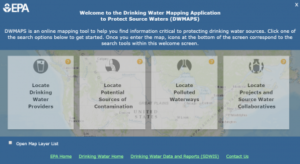
Welcome page of DWMAPS displays search tools for users to find information about drinking water sources.
This robust, online mapping tool provides the public, water system operators, state programs, and federal agencies with critical information to help them safeguard the sources of America’s drinking water.
The DWMAPS – the Drinking Water Mapping Application to Protect Source Waters – allows users to learn about their watershed and understand more about their water supplier. The DWMAPS also allows users to see if sources of their drinking water are polluted and if there are possible sources of pollution that could affect their community’s water supply. The tool can even guide users to ways they can get involved in protecting drinking water sources in their community.
For more information and to access the map visit http://www.epa.gov/sourcewaterprotection/dwmaps.
