GIS

NAR Activities Now Available on RR Sites Map

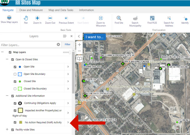
DNR staff recently completed a project which added geographic information for No Action Required (NAR) activities on RR Sites Map.

NAR activities are sites where after notification of a hazardous substance discharge the DNR determined that the responsible party did not need to undertake an investigation or cleanup in response to that discharge because there was no or insignificant contamination.

This information is accessible as a new layer on RR Sites Map and the DNR GIS Open Data Portal. This layer provides users with direct access to over 11,000 additional activity locations on RR Sites Map.

Users can access map layers by selecting Navigate on the top menu bar. Select “Show Map Layers” and expand the “Additional Site Information” menu to check the “No Action Required (NAR) Activity” layer. This will populate the map with small yellow boxes with an activity number beginning with “09.” The prefix “09” is used for NAR activities in BRRTS on the Web (BOTW).


RR Program’s Contaminated Sites Database Viewer Updated

The Remediation and Redevelopment (RR) program has updated the public interface of its online database of open and closed cleanup sites with new functions and a style that matches the DNR’s redesigned website.

BRRTS On The Web (BOTW) is our searchable, public database that allows users to find information about the investigation and cleanup of environmental contamination in Wisconsin.

Continue reading “RR Program’s Contaminated Sites Database Viewer Updated”

Reminder to Respond: RR Sites Map Survey Ending Soon

Time is running out on the opportunity to complete a brief survey to help guide future refinements of the Remediation and Redevelopment (RR) Program’s RR Sites Map (RRSM).

RR Sites Map is the visual component and counterpart to the Bureau for Remediation and Redevelopment Tracking System (BRRTS) on the Web (BOTW).

The RR Program seeks to gain a better understanding of how customers use the application’s existing tools and features, while also gathering suggestions for improvements.

The survey results will help guide future developments of RR Sites Map, ultimately making RRSM a more useful tool.

Staff will accept survey results through the middle of January 2021.

RR Program Seeks Input on Map Tool

The Remediation and Redevelopment (RR) Program seeks your input and advice that will help guide future refinement of the RR Sites Map (RRSM), the visual component and counterpart to the Bureau for Remediation and Redevelopment Tracking System (BRRTS) on the Web (BOTW).

A brief survey is now available to gather your feedback on the RR Sites Map. The RR Program wants to gain a better understanding of the customers who use the application and how they use it.

Continue reading “RR Program Seeks Input on Map Tool”

New Features for RR Sites Map

RR Sites Map is the online companion to the DNR’s Remediation and Redevelopment database of known environmental contamination and cleanup cases in Wisconsin. It allows users to find sites visually and geographically, and then drill down into the database for further details, if desired. 

RR Sites Map Screenshot

RR Sites Map is part of the DNR’s Wisconsin Remediation and Redevelopment Database (WRRD), an inter-linked system tracking information on different contaminated land activities.

RR Sites Map works on desktop computers, phones, and other mobile devices. It’s a great way to get information about closed and continuing remediation activities.

The DNR seeks to continually improve user experiences with this application. Recent updates include:

  • Removed the “GIS Registry” layer group. 
    • The term “GIS Registry” was used in the past to refer to sites that were closed with residual contamination. The DNR now uses the term “Continuing Obligations”, along with a list of these obligations in the closure letter, to let the public know residual contamination exists and that some ongoing requirements exist to continue protecting public health. Sites with “Continuing Obligations” now have their own layer.
  • Added the new “Additional Site Information” layer group. 
    • This new layer group includes both the new “Continuing Obligations” layer and preexisting “Impacted Another Property” layer, which identifies sites with migrating contamination. 
  • Added aerial photos from 2017 to the base maps and image slider tool. 
  • Changed the name of the “Contaminated and Cleaned Up Sites” layer group to “Open & Closed Sites.” 
  • Added a “Layer Catalog” button to the data and tasks tab. 
    • After clicking the button, select the desired GIS data layers and they will appear in the left-side layers panel along with the default layer options.
    • New layer options include: DNR office locations; private water well locations; dual aquifers; landfills with 1,200-foot buffers; areas where special well casing is required; and other agency data such as soil types, hydric ratings and drainage classes.

Let us know how you use RR Sites Map, and please share your suggestions for improvement by emailing them to DNRRRBRRTSFeedback@wisconsin.gov.

Wisconsin’s Remediation and Redevelopment Database

RR Sites Map Mobile Device

RR Sites Map is accessible via desktop computers, tablets and smart phones.

The Remediation and Redevelopment (RR) Program in the DNR oversees the investigation and cleanup of environmental contamination and the redevelopment of affected properties in Wisconsin. The RR Program also maintains a public database that contains information about known hazardous substance discharges to the environment, investigations, cleanup activities, closure requests, remaining actions needed, spills requiring emergency attention and more. This public database is called the Bureau of Remediation and Redevelopment Tracking System (BRRTS) on the Web (BOTW).

BOTW is augmented by an associated GIS mapping application, called RR Sites Map, which provides a visual representation of data available in BOTW. This interactive map allows users to geographically search for open and closed sites, obtain basic information about a site, click on a link that goes directly to full site information, and more. RR Sites Map is accessible via desktop computers, tablets and smart phones.

Together, BOTW and RR Sites Map are collectively referred to as the Wisconsin Remediation and Redevelopment (RR) Database (WRRD). These two public tools provide easy online access to detailed information about conditions and environmental activities at tens-of-thousands of cleanup sites around the state. This database was formerly referred to as CLEAN, the Contaminated Lands Environmental Action Network.